

• Haiti Rebuilding Initiative • Kristina Alvarez, Sharon Clay, and Amy Marino. Urban Planning Group 1. M. Fox, Instructor, Cal Poly Pomona Architecture, Fall 2010.
Sunday, October 31, 2010

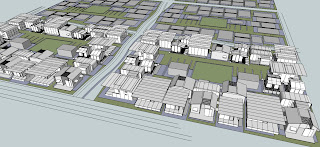
quarter of a mile grid layout
Quarter of the one squared mile grid. This grid tries to provide more mixed-use (housing units with a small retail component possibly their porch area) buildings along the larger streets (perimeter streets). While having secondary streets run through the entire grid and tertiary streets within the grid. The green outlined zones are designated for city facilities.

Wednesday, October 27, 2010
Information and calculations on latest data for 10.27.2010
Square mile = 5,280 ft. x 5,280 ft. = 27,878,400 sq. ft.
Square block = 300 ft. x 150 ft. = 45,000 sq. ft.
5,280 ft. - 340 ft. (accounting for road footage in the x direction) = 4,940 ft.
5,280 ft. - 640 ft. (accounting for road footage in the y direction) = 4,640 ft.
4,940 x 4640 = 22,921,600 sq ft of block space
22,921,600 total block area / 45,000 sq ft per block = ~509 blocks
22,921,600 total block area / 45,000 sq ft per block = ~509 blocks
Thus 509 blocks will fit into the square mile grid not counting road space.
400 blocks designated to housing, 109 blocks designated to community needs space
400 blocks x 400 people per block = 160,000 people per square mile
60% are school age
160,000 x .6 = 96,000 people (children) will need to attend school, per square mile.
Assuming that one floor on one block could provide for 500-650 students, including admin, support, cafeteria and play area, at one time. Considering that the schools should be a two story permanent structure and could meet twice a day, each school block can provide for 2600 students. We are going to allow for 37-40 school blocks.
Assuming that one floor on one block could provide for 500-650 students, including admin, support, cafeteria and play area, at one time. Considering that the schools should be a two story permanent structure and could meet twice a day, each school block can provide for 2600 students. We are going to allow for 37-40 school blocks.
2PART SANITATION SYSTEM:
1.The residential blocks will be served, at least initially, common facilities. This centralization is a great opportunity to institute composting toilets, collection and fertilizer depot. Creating this infrastructure will provide much needed fertilizer for much needed intensive agriculture.
Soil is a non profit working to provide composting toilets in and outside of Haiti right now.
http://www.oursoil.org/
2. The secondary spacial drivers in these developments will be educational facilities to serve 60% of the population. These high density schools will be excellent opportunity to install solid waste bio-fuel processing, which have been installed in discrete institutions and developments all over the world. Bio-fuel has two valuable bi-products for humane life, in addition to sustainably processing waste. The bi-products are gas, which can be used for cooking in the schools, or if plentiful, used as fuel for a co-generator. Also the solid waste digesters begin the process for creating fertilizer. That product can also be collected and taken to the fertilizer depot.
Here are some examples of bio-fuel projects:
http://www.ashdenawards.org/biogas
Renderings of houses with Bathroom design included (+/- people and tree settings)
Our bathroom design includes 10 toilets per building and 5 showers, with sinks lining one exterior side (lengthwise) of the building. Each block would feature two of the bathroom units. (400 people =>20 toilets @ 20 people per toilet). One unit would be for women and the other for men, with sinks usable to all...
(Bathroom measures 16' x 26.5' with sinks.
The tilted roof measures 23' x 29' with 1' overhangs on both sides, 5' overhang over sinks, and 3.5' overhang over bathroom and shower entry wall.
Height: is 8' on low end and 9' 4" on high end with openings.
Sinks: 3' high.)


(Bathroom measures 16' x 26.5' with sinks.
The tilted roof measures 23' x 29' with 1' overhangs on both sides, 5' overhang over sinks, and 3.5' overhang over bathroom and shower entry wall.
Height: is 8' on low end and 9' 4" on high end with openings.
Sinks: 3' high.)


Tuesday, October 26, 2010
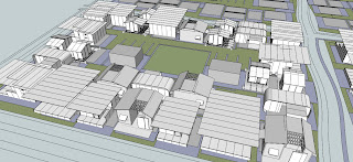
one squared mile grid
Another attempt to design the overall layout of a city grid, which is a one squared mile. In this scheme, we have 30 feet roads every quarter of a mile and alternating 15 and 20 feet roads within the entire layout. There are three different neighborhood blocks: the simple rectangle block; the almost square block and the long, thin rectangle.


The second image is a zoom in of the top image. The shaded green areas are examples in which neighborhood blocks could be connected with pedestrian or vehicular paths, which will link open spaces. The number and size in which blocks are connected can greatly vary.

Monday, October 25, 2010
TYPICAL FACILITIES BUILDING, SINGLE SEX, TWO PER BLOCK (400 people arox)
I have been trying to find numbers on how many restrooms should be provided in a high density, new urbanization project with no luck.
Finally my best source was my brother who managed 4 of the largest post Katrina camps. He said FEMA tried to provide 1 toilet per 15-20 people. There are of course some key differences in the situation. Most importantly FEMA was dealing with porter potties and they HAD to be emptied on a daily basis.
I am fairly confidant that these Haiti sites will not have enough space or resources to pump toilets.
The second key difference is that the typical diet of an American and a Haitian, are, well, very different.
So, we arrived at the number one toilet per 25 people. In his experience this would not leave people waiting for long periods.
So the question remains what kind of system should be used.
- conventional sewer systems are expensive to install, and maintain and are a strain on the environment to maintain.
- septic systems create a similar environmental problem, are less expensive to install, but require semi-regular maintenance.
- composting toilets require some maintenance on the part of the user and a considerable amount of effort on the part of the municipality. They are, however, much more healthy for the environment and the users.
- a Bio-fuel waste system is in ways a cross in between a conventional sewer and composing toilets. Many have been put in place around the world and are extremely successful. It involves a localized system that collects into a digester, and creates extremely beneficial bi-products of bio-gas and fertilizer.
Note, that no mater the system, the building should be on a plinth, the height of which depends on the system.
High estimate of people per block = 400/25 = 16, 8 per sex
As many sinks have been provided for cooking, washing, and general sanitation. The area in front of the sinks should be generous, as it will most likely become a place for socializing.
4 showers have been provided.

A stab at renderings in one of our urban schemes with versions of each of the housing teams' houses
This depicts the density of the situation and a rough version of how the end result will look.


Sunday, October 24, 2010
connecting open spaces scheme 2
This diagram shows neighborhood blocks' open spaces that are connected with pedestrian or vehicular paths. There can be three to four paths that leads out of a neighborhood block into three or four other ones. The pedestrian and vehicular paths vary in length and width.


block scheme with group 1's houses
This image shows the numerous combination adjacencies of different neighborhood block layouts of the simple rectangle and the almost square blocks. The simple rectangle blocks contains all three sizes (250 s.f., 400 s.f., and 600 s.f.) houses by Group 1: John, Tyler and Nate.
In addition, the almost square blocks, is the same size as the simple rectangle, but the layout of the houses form two C courtyards blocks, which face each other, with a vehicular access path in between. This block also labels what is happening within the courtyard spaces.

Saturday, October 23, 2010
the almost square block scheme with group 2's houses
The almost square blocks together contains 28 units using Group 2's (Julie, Kelleen, Layla and Eylyana) houses. Group 2's houses actually dropped the number of houses we originally thought we could have for this block scheme. Therefore, we believe that Group 2's houses should probably not be laid out in this block scheme in order to reach maximum density. Adjacent to the almost square blocks is a simple rectangle block with no houses indicated on the designated plots.
 a
a
 a
aFriday, October 22, 2010
Wednesday, October 20, 2010


Monday, October 18, 2010


plan view for third block scheme
Here is a plan view of our third neighborhood block scheme with a curving road to the south. The courtyard contains women/children and men's restrooms, parking and a community garden. The block has two openings to the rest of the city by an access road that cuts through the block.

Data for third scheme
29 units per block (same as first scheme plan and low end of second scheme plan):
People per unit:
People per unit:
• 250 s.f. = 4 people
• 400 s.f. = 8 people
• 600 s.f. = 12 people
Units per block: 29 total
People per block based on these numbers:
• 208 people
Blocks per square mile:
• 768 blocks total each 200'x150'
• 80 (200' x 150' plots) reserved for city use (that's 2,400,000 s.f.)
• 688 reserved residential compounds
• Units: 688x29 = holds 19,952 units total
• People: 688x208 = holds 143,104 people
In a one square mile city


Subscribe to:
Posts (Atom)